Bigfoot 40
Destination Trail, Bigfoot 40 ( https://www.destinationtrailrun.com/ )
This was my first attempt at anything larger than a 50K, and my first dip back into the game after having a down season due to a crazy job. I signed up with around 6 weeks to actually train and get my act together, and the location, remoteness, and limited aid were all huge draws!
It was hard, and hot, but one of the best runs of my life. A very challenging day, and I'm proud of my time of 12:24! ( Ultrasignup )
Below the photo, is the link to my Flickr album with a bunch of pictures and videos taken around the event.
----------------------------------------------------------------------------
Edit after the fact, here's a link to the quick breakdown on my gear, to see what I packed Bigfoot 40 gear
----------------------------------------------------------------------------
So here we go.
I quit an overly stressful job earlier in the year and was finally able to stoke my passion for running again. I was increasing my mileage, slowly working my way back up to long distances, when my wife started telling me about a co-workers’ ultra training. Well, one thing led to another, and very quickly I found the Bigfoot races in Washington.
I, like many people perhaps, am intrigued by Mount St Helen's, it blew in 1980 the same year I was born, and living on the west coast it was always something I was aware of and vaguely recall driving by in the backseat of the car on childhood road trips to the north.
Besides the act of pushing myself to my limits to see what I am capable of, my running is additionally fueled by the act of exploring, discovering new things, traveling great distances on my own 2 feet. No road running, no repetitive pace requirements (minus cut off), and absolutely no easy way to quit. I want a challenge, I want to accomplish things that not everyone can do.
So, Bigfoot. I’m not ready for a 200, and before this race had never ran more than a 50K, so a 40 mile race (ok, closer to 43 maybe) sounded like a great move, so with around 6 weeks of true prep, I signed up and booked our travel accommodations. Now the fun began, I had purpose and a goal.
I quickly ordered a few Ultimate Direction packs and a few pairs of my Inov-8 shoes to start to figure it out and cranked up the training.
Fast forward to the trip, the day prior, we ran errands and stocked up on last minute supplies, explored southern Washington, scoped out the course start line, and finally got in a late meal at the local casino (FYI, most of the local restaurants close early), nothing says race prep quite like chicken Alfredo from a casino bar restaurant…
But you’re here for the race.
What can I say that you haven’t researched so far (and hopefully you’ve done that by now). The general concept is you climb from the start line, up to the trail, where you run around the mountain, to then return down to the finish. That initial climb is respectable (around 2k feet), and since it’s the start, the crowd is thick. Yeah, like most runners, I like to pass the next person, but I’m also decent with climbs like that, so I was able to put myself in a good position as the pack started to thin out.
It’s still early in the day so the sun is low, and as you get up to the primary trail you get wonderful views of the surrounding land. Now you’re coming up on more runnable trail, single track through meadows, shaded trail under tree canopy, and the occasional boulder field, they’re big rocks so it’s not the worst, but at the same time, you have to pick and choose your route carefully, while trying to find the course, so take your time, no need to roll an ankle this early in the day.
Continuing on, the trail feels like you’d expect for a gorgeous PNW run, it’s late in the summer so everything is green and growing, you get to run through meadows, under old trees, in and out of shade, and as you slowly approach the first aid station you may start seeing other racers going opposite (my year, the 20 milers ran a backwards loop). If you didn’t kill yourself on the initial climb, this is a great place to just get into your groove, run & walk, and enjoy the scenery.
Soon enough, you hit Blue Lake Aid, where you get to stock up and refill and eat and do the drop bag thing if you do that. Definitely fill up on water here, the next stretch is around 16 miles until the next aid station, and it’s exposed.
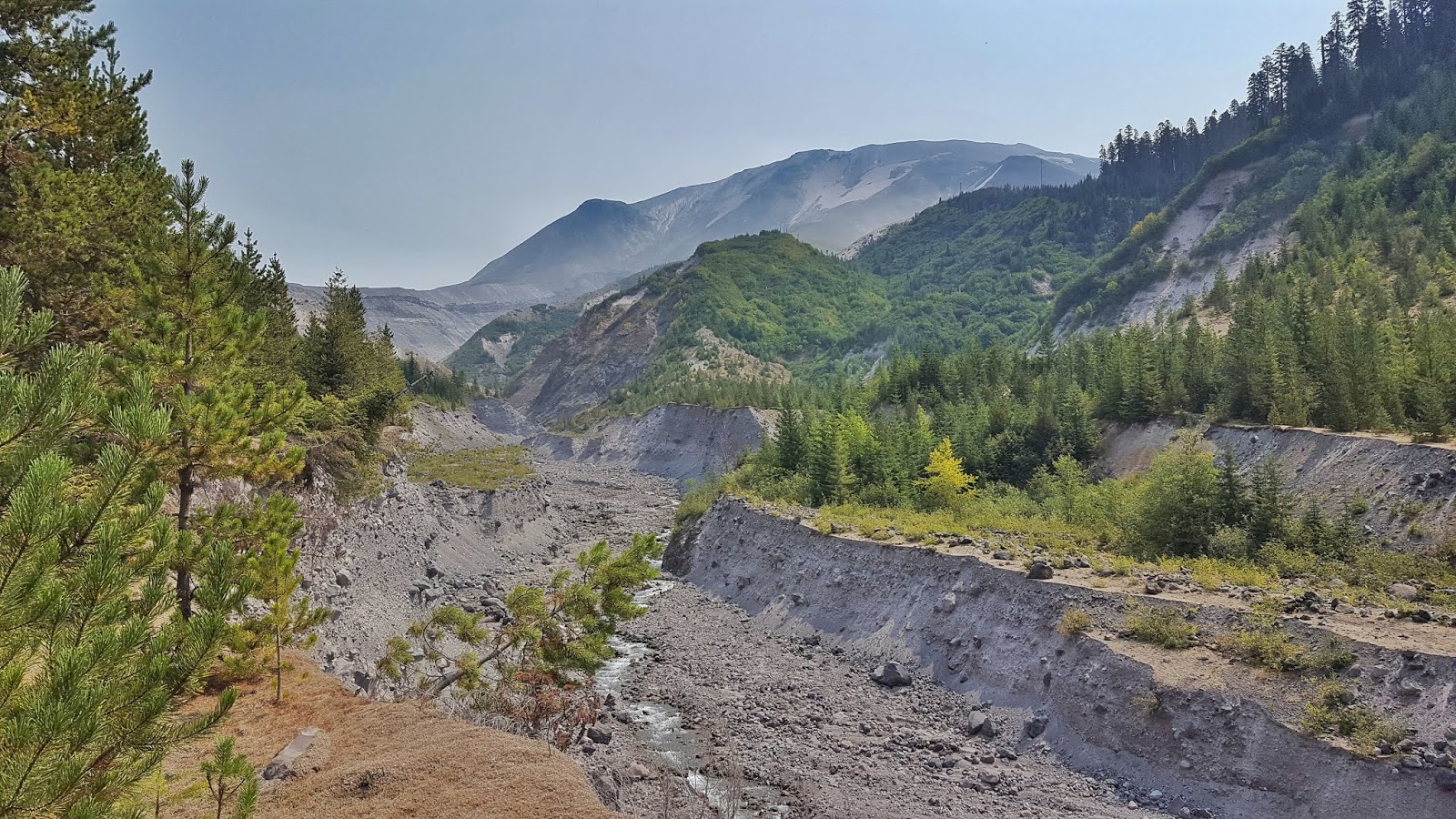
One more run through some level forest and around a lake, and you start to see more washes and a ravine, you start to get a better view of the blown out mountain top, and you remember you’re actually running around a volcano that has erupted in recent years.
It’s hot, sunny, and exposed. The terrain is a mixture of lava rock, hard pack dirt, soft forest trail, and a bunch of ash. This is the first race where I wore gaiters, and minus a few learning issues, I feel they helped keep my feet in good shape, despite the dirt and dust.
As you continue, you get more and more into the blast zone, less life exists and more lava rock and ash, eventually you get to an area where nothing exists except perhaps a little grass, I advise you fill up your water at the creeks when able, since it’s scarce. Also was a great place to actually communicate with other runners, since by now the field has thinned considerably. Definitely bring a water filter bottle, the silt/ash is in the water and may not be the best to drink.
*advice, don’t get careless like I did. As I sat by a creek filtering water from my bottle to my bladder, I let my bladder flop over where it hit, and sliced open on a sharp lava rock. Luckily for me, it was a 3L bladder and the split was above the filler hole, so I was able to fill it and keep a few liters of water in, where it only leaked if I leaned over, but had it split lower, that would have negatively impacted my ability to survive, cause it’s damn hot out there.
(note, Camelbak has a lifetime warranty, and after sending them my 10 year old damaged bladder they sent me a brand new mil spec 3L bladder for free, definitely appreciated that!)
So you’re out in the dead zone of a volcano, it’s absolutely awesome to see it on foot, to realize that life was wiped off of this place by a violent act of nature. Way off to your left is Spirit Lake, which you get to see from a distance unless you’re running the 100 or 200. Off you go, onto the long road to aid station # 2.
I was lucky, my wife was there to crew me (and she had a great time helping out with the race), so aid #2 was where I got myself a bacon/cheese quesadilla and half a beer (along with a lot more food), and while that may have not been the perfect nutrition, it was a damn nice change from the packed foods and gels and such, definitely good for the soul.
I changed socks here, which I shouldn’t have since they were new socks which ended up not doing well, but, that’s why you’re not supposed to try new things on race day. But since I had a gaiter rip early on, I hoped a clean/dry sock would be better.
Off you go, down that road back to the course, and I don’t want to ruin the surprise, but there’s definitely a fierce climb coming, short and sweet, and if you’re on the edge of a cramp, this will bring it for sure. But once you crest that, you’re back on runnable trail, albeit hot and exposed. More varied terrain, more exposure, weird canyons and washes and crevices, but eventually you’ll make it through and to a glorious field of Huckleberries (my personal favorite), I took a few minutes to relax and wind down and stretch as I ate some berries, allowing myself to regather my mind.
You do start to dip in and out of forest, a few more boulder fields to navigate, I was lucky and made good time, so I made it through all of this before it got dark. Matter of fact, I was working my way down the final miles to the finish when I realized I was almost done, so I didn’t even have to get my lamp out. Once I realized where I was, regardless of foot fatigue and a slippery blister feeling that was growing, I ran, as fast as my tired legs could, I was ecstatic that I had made the time as good as I was, and wanted to push the final distance as much as possible.
Sure as hell, I finished before dark, with a final time of around 12:25, which was somewhere 35-95 minutes quicker than I had hoped for, so I was absolutely happy!
(my ambitious goal was under 13 hours, my realistic goal was under 14)
At the finish line.
Shoes off immediately.
Finally able to relax and smile (apparently I didn’t do that for days prior as I mentally prepared)
Yeah I grabbed a beer, but proper hydration was more appealing for that moment.
Sat down, ate, relaxed, reveled in this monumental accomplishment that I had just done.
The sun had set, the moon was rising, and it was a perfect closure to the day.
I don’t remember the rest of the night, the run was hard, and the exposure and sun definitely take their toll, but it was an experience of a lifetime, and the race organizers, volunteers, and fellow runners all made that happen. Just a reminder of why I love trails, the community, and the places we can go, stick with us for a lifetime.
I’m writing this up 9 months after the race, so I of course remember the good and forget the hurt, but this was really a fantastic day, and my training held up, as short as it may have been (although I had a solid foundation).
I’ve met several great people through this race alone, both online and in person, and am looking forward to more. I’m not ready for a 200 miler, but would definitely return if a 100M race happened here :)
While you have no cell service, GPS works great, and my Garmin Fenix 3 held up without issue, so here's my workout,
As for a high level overview, here is are some rough ideas on distance for the course (ran clockwise):
1-2: the initial climb.
2-11: the nice leg, several boulder fields yes, but also a lot of forest as you wind your way towards the first aid station.
11-16: more forest on the green side of the mountain, but plenty of views, and several challenging sections.
16-27: the blast zone, hot, arid, a few tiny creeks to pull water from until you get to the 2nd aid station.
27-37: more exposed and hot terrain, not much cover and by now it’s the heat of the day.
37-39: a return to the forest, some shade, sun is probably getting close to setting and being hidden behind the mountain.
39-finish: downhill, almost there!
And finally, here's the Cal Topo map provided by Destination Trail.
As a back country person who's yet to be lost, and never wants to be, I suggest a paper map as well as a digital map, both are easy to get for cheap or free, and could very well save your butt.
Also, a hiker was lost in this area at the same time as the race, where he barely survived and was out there for many days, so while the course is marked great, never take it for granted, this is an isolated area and you're responsible for your own safety.
If you're on the fence, and think you can do this, I say you do it, it's a memory that will last a lifetime, and who knows what kind of doors it may open!
This was my first attempt at anything larger than a 50K, and my first dip back into the game after having a down season due to a crazy job. I signed up with around 6 weeks to actually train and get my act together, and the location, remoteness, and limited aid were all huge draws!
It was hard, and hot, but one of the best runs of my life. A very challenging day, and I'm proud of my time of 12:24! ( Ultrasignup )
Below the photo, is the link to my Flickr album with a bunch of pictures and videos taken around the event.
 |
| Flickr Album |
----------------------------------------------------------------------------
Edit after the fact, here's a link to the quick breakdown on my gear, to see what I packed Bigfoot 40 gear
----------------------------------------------------------------------------
So here we go.
I quit an overly stressful job earlier in the year and was finally able to stoke my passion for running again. I was increasing my mileage, slowly working my way back up to long distances, when my wife started telling me about a co-workers’ ultra training. Well, one thing led to another, and very quickly I found the Bigfoot races in Washington.
I, like many people perhaps, am intrigued by Mount St Helen's, it blew in 1980 the same year I was born, and living on the west coast it was always something I was aware of and vaguely recall driving by in the backseat of the car on childhood road trips to the north.
Besides the act of pushing myself to my limits to see what I am capable of, my running is additionally fueled by the act of exploring, discovering new things, traveling great distances on my own 2 feet. No road running, no repetitive pace requirements (minus cut off), and absolutely no easy way to quit. I want a challenge, I want to accomplish things that not everyone can do.
So, Bigfoot. I’m not ready for a 200, and before this race had never ran more than a 50K, so a 40 mile race (ok, closer to 43 maybe) sounded like a great move, so with around 6 weeks of true prep, I signed up and booked our travel accommodations. Now the fun began, I had purpose and a goal.
I quickly ordered a few Ultimate Direction packs and a few pairs of my Inov-8 shoes to start to figure it out and cranked up the training.
Fast forward to the trip, the day prior, we ran errands and stocked up on last minute supplies, explored southern Washington, scoped out the course start line, and finally got in a late meal at the local casino (FYI, most of the local restaurants close early), nothing says race prep quite like chicken Alfredo from a casino bar restaurant…
But you’re here for the race.
What can I say that you haven’t researched so far (and hopefully you’ve done that by now). The general concept is you climb from the start line, up to the trail, where you run around the mountain, to then return down to the finish. That initial climb is respectable (around 2k feet), and since it’s the start, the crowd is thick. Yeah, like most runners, I like to pass the next person, but I’m also decent with climbs like that, so I was able to put myself in a good position as the pack started to thin out.
It’s still early in the day so the sun is low, and as you get up to the primary trail you get wonderful views of the surrounding land. Now you’re coming up on more runnable trail, single track through meadows, shaded trail under tree canopy, and the occasional boulder field, they’re big rocks so it’s not the worst, but at the same time, you have to pick and choose your route carefully, while trying to find the course, so take your time, no need to roll an ankle this early in the day.
Continuing on, the trail feels like you’d expect for a gorgeous PNW run, it’s late in the summer so everything is green and growing, you get to run through meadows, under old trees, in and out of shade, and as you slowly approach the first aid station you may start seeing other racers going opposite (my year, the 20 milers ran a backwards loop). If you didn’t kill yourself on the initial climb, this is a great place to just get into your groove, run & walk, and enjoy the scenery.
Soon enough, you hit Blue Lake Aid, where you get to stock up and refill and eat and do the drop bag thing if you do that. Definitely fill up on water here, the next stretch is around 16 miles until the next aid station, and it’s exposed.
One more run through some level forest and around a lake, and you start to see more washes and a ravine, you start to get a better view of the blown out mountain top, and you remember you’re actually running around a volcano that has erupted in recent years.
It’s hot, sunny, and exposed. The terrain is a mixture of lava rock, hard pack dirt, soft forest trail, and a bunch of ash. This is the first race where I wore gaiters, and minus a few learning issues, I feel they helped keep my feet in good shape, despite the dirt and dust.
As you continue, you get more and more into the blast zone, less life exists and more lava rock and ash, eventually you get to an area where nothing exists except perhaps a little grass, I advise you fill up your water at the creeks when able, since it’s scarce. Also was a great place to actually communicate with other runners, since by now the field has thinned considerably. Definitely bring a water filter bottle, the silt/ash is in the water and may not be the best to drink.
*advice, don’t get careless like I did. As I sat by a creek filtering water from my bottle to my bladder, I let my bladder flop over where it hit, and sliced open on a sharp lava rock. Luckily for me, it was a 3L bladder and the split was above the filler hole, so I was able to fill it and keep a few liters of water in, where it only leaked if I leaned over, but had it split lower, that would have negatively impacted my ability to survive, cause it’s damn hot out there.
(note, Camelbak has a lifetime warranty, and after sending them my 10 year old damaged bladder they sent me a brand new mil spec 3L bladder for free, definitely appreciated that!)
So you’re out in the dead zone of a volcano, it’s absolutely awesome to see it on foot, to realize that life was wiped off of this place by a violent act of nature. Way off to your left is Spirit Lake, which you get to see from a distance unless you’re running the 100 or 200. Off you go, onto the long road to aid station # 2.
I was lucky, my wife was there to crew me (and she had a great time helping out with the race), so aid #2 was where I got myself a bacon/cheese quesadilla and half a beer (along with a lot more food), and while that may have not been the perfect nutrition, it was a damn nice change from the packed foods and gels and such, definitely good for the soul.
I changed socks here, which I shouldn’t have since they were new socks which ended up not doing well, but, that’s why you’re not supposed to try new things on race day. But since I had a gaiter rip early on, I hoped a clean/dry sock would be better.
Off you go, down that road back to the course, and I don’t want to ruin the surprise, but there’s definitely a fierce climb coming, short and sweet, and if you’re on the edge of a cramp, this will bring it for sure. But once you crest that, you’re back on runnable trail, albeit hot and exposed. More varied terrain, more exposure, weird canyons and washes and crevices, but eventually you’ll make it through and to a glorious field of Huckleberries (my personal favorite), I took a few minutes to relax and wind down and stretch as I ate some berries, allowing myself to regather my mind.
You do start to dip in and out of forest, a few more boulder fields to navigate, I was lucky and made good time, so I made it through all of this before it got dark. Matter of fact, I was working my way down the final miles to the finish when I realized I was almost done, so I didn’t even have to get my lamp out. Once I realized where I was, regardless of foot fatigue and a slippery blister feeling that was growing, I ran, as fast as my tired legs could, I was ecstatic that I had made the time as good as I was, and wanted to push the final distance as much as possible.
Sure as hell, I finished before dark, with a final time of around 12:25, which was somewhere 35-95 minutes quicker than I had hoped for, so I was absolutely happy!
(my ambitious goal was under 13 hours, my realistic goal was under 14)
At the finish line.
Shoes off immediately.
Finally able to relax and smile (apparently I didn’t do that for days prior as I mentally prepared)
Yeah I grabbed a beer, but proper hydration was more appealing for that moment.
Sat down, ate, relaxed, reveled in this monumental accomplishment that I had just done.
The sun had set, the moon was rising, and it was a perfect closure to the day.
I don’t remember the rest of the night, the run was hard, and the exposure and sun definitely take their toll, but it was an experience of a lifetime, and the race organizers, volunteers, and fellow runners all made that happen. Just a reminder of why I love trails, the community, and the places we can go, stick with us for a lifetime.
I’m writing this up 9 months after the race, so I of course remember the good and forget the hurt, but this was really a fantastic day, and my training held up, as short as it may have been (although I had a solid foundation).
I’ve met several great people through this race alone, both online and in person, and am looking forward to more. I’m not ready for a 200 miler, but would definitely return if a 100M race happened here :)
While you have no cell service, GPS works great, and my Garmin Fenix 3 held up without issue, so here's my workout,
 |
| Garmin.com |
1-2: the initial climb.
2-11: the nice leg, several boulder fields yes, but also a lot of forest as you wind your way towards the first aid station.
11-16: more forest on the green side of the mountain, but plenty of views, and several challenging sections.
16-27: the blast zone, hot, arid, a few tiny creeks to pull water from until you get to the 2nd aid station.
27-37: more exposed and hot terrain, not much cover and by now it’s the heat of the day.
37-39: a return to the forest, some shade, sun is probably getting close to setting and being hidden behind the mountain.
39-finish: downhill, almost there!
And finally, here's the Cal Topo map provided by Destination Trail.
 |
| Caltopo.com |
As a back country person who's yet to be lost, and never wants to be, I suggest a paper map as well as a digital map, both are easy to get for cheap or free, and could very well save your butt.
Also, a hiker was lost in this area at the same time as the race, where he barely survived and was out there for many days, so while the course is marked great, never take it for granted, this is an isolated area and you're responsible for your own safety.
If you're on the fence, and think you can do this, I say you do it, it's a memory that will last a lifetime, and who knows what kind of doors it may open!


Comments
Post a Comment